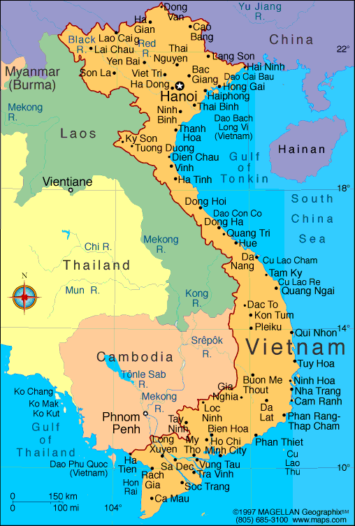
Vietnam is located on the eastern margin of the Indochinese peninsula and occupies about 331,688 square kilometers, of which about 25 % was under cultivation in 1987. It borders the Gulf of Thailand, Gulf of Tonkin, and South China Sea, alongside China, Laos, and Cambodia. The S-shaped country has a north-to-south distance of 1,650 kilometers and is about 50 kilometers wide at the narrowest point. With a coastline of 3,260 kilometers, excluding islands, Vietnam claims 12 nautical miles (22.2 km; 13.8 mi) as the limit of its territorial waters, an additional 12 nautical miles (22.2 km; 13.8 mi) as a contiguous customs and security zone, and 200 nautical miles (370.4 km; 230.2 mi) as an exclusive economic zone.
The boundary with Laos, settled, on an ethnic basis, between the rulers of Vietnam and Laos in the mid-seventeenth century, was formally defined by a delimitation treaty signed in 1977 and retified in 1986. The frontier with Cambodia, defined at the time of French annexation of the western part of the Mekong River Deltain 1867, remained essentially unchanged, according to Hanoi, until some unresolved border issues were finally settled in the 1982-85 period. The land and sea boundary with China, delineated under the France-China treaties of 1887 and 1895, is "the frontier line" accepted by Hanoi that China agreed in 1957- 58 to respect. However, in February 1979, following China's limited invasion of Vietnam, Hanoi complained that from 1957 onward China had provoked numerous border incidents as part of its anti-Vietnam policy and expansionistdesigns in Southeast Asia. Among the territorial infringements cited was the Chinese occupation in January 1974 of the Paracel Islands, claimed by both countries in a dispute left unresolved in the 1980s.
Vietnam Geography
Located in the southeastern extremity of the Indochinese peninsula, Vietnam spreads over an area of about 331,690 sq.kms. Vietnam shares a border with the Gulf of Tonkin, Gulf of Thailand, South China Sea alongside China, Laos and Cambodia. What makes Vietnam Geography remarkable is its S-shaped coastline that runs for as long as 3,260 kilometers.
Geography of Vietnam can be divided in to four sections that range from rugged mountains to marshy fertile flatlands. Towards the south lies the Gulf of Thailand, towards the east and southeast lies the Red River Delta. China lies towards the north then there are mountains extending up to 3.143 m at Fan Si Pan, which is also know as the highest point in Vietnam.
Tropical lowlands, hills, densely forested highlands and deltas are some of the major geographical features of Vietnam. The Red River Delta is a triangular region covering 3,000 sq,kms and is densely populated than the Mekong River Delta. Owing to its low level which is just 3 km above sea level, the entire delta region is subject to frequent flooding.
Vietnam enjoys a varied climate. The weather in Vietnam is controlled by two monsoons, one of them is the dry monsoon and the other is the wet one. In the north the average temperature extends up to 27 degrees C and 21 degrees C in the south. Avoid traveling to Vietnam during from July to August, which is the hottest and the most humid period in Vietnam. The annual rainfall received in Vietnam ranges from 1200 centimeters to 300 centimeters.
Best Time to Visit Vietnam: Traveling to Vietnam can be enjoyed all round the year, however as mentioned before, one should avoid traveling to Vietnam between June to August, which is the wet season and is considered as the hottest and the most humid period of the year. Hanoi Sightseeing in Vietnam can be best enjoyed between December to February, when the north Vietnam tends to be cool and often misty.

Demographics of Thailand
From Wikipedia, the free encyclopedia
This article is about the demographic features of the population of Thailand, including population density, ethnicity, education level, health of the populace, economic status, religious affiliations and other aspects of the population.
Thailand's population is relatively homogeneous, however, this is changing due to immigration. More than 85% speak a Tai language and share a common culture. This core population includes the central Thai (33.7% of the population, including Bangkok's population), Northeastern Thai or Lao (34.2%), northern Thai (18.8%), and southern Thai (13.3%).
The language of the central Thai population is the educational language and administrative language. Several other small Tai groups include the Shan, Lue, andPhutai.
Up to 14% of Thailand's population are of Chinese descent, but the Sino-Thai community is the best integrated in Southeast Asia. Malay and Yawi-speaking Muslims of the south comprise another significant minority group (2.3%). Other groups include the Khmer; the Mon, who are substantially assimilated with the Thai; and the Vietnamese. Smaller mountain-dwelling tribes, such as the Hmong and Mein, as well as the Karen, number about 788,024. Some 300,000 Hmong, who ironically have lived this area for more generations than the Thais themselves, are to receive citizenship by 2010.[citation needed]
Thailand is also home to a significant number[quantify] of registered foreigners from Asia, Europe, and North America, as well as an estimated several hundred thousand illegal immigrants, some of which are natives. Increasing numbers of migrants from Burma, Laos, and Cambodia as well as nations such as Nepal, India, along with those from the West and Japan have pushed the number of non-nationals residing in Thailand to close to 2 million in 2008, up from about 1.3 million in the year 2000. A rising awareness of minorities is slowly changing attitudes in a country where non-nationals, some having resided in what is now Thailand longer than the Thais themselves, are barred from numerous privileges ranging from healthcare, ownership of property, or schooling in their own language.
The population is mostly rural, concentrated in the rice-growing areas of the central, northeastern, and northern regions. However, as Thailand continues to industrialize, its urban population - 31.1% of the total population, principally in the Bangkok area - is growing.
Thailand's highly successful government-sponsored family planning program has resulted in a dramatic decline in population growth from 3.1% in 1960 to around 0.4% today. Life expectancy also has risen, a positive reflection of Thailand's efforts in executing public health policies. However, the AIDS epidemic has had a major impact on the Thai population. Today, over 700,000 Thais are HIV or AIDS positive - approximately 2% of adult men and 1.5% of adult women. Every year, 30,000-50,000 Thais die from HIV or AIDS-related causes. Ninety percent of them aged 20–24, the youngest range of the workforce. The situation could have been worse; an aggressive public education campaign in the early 1990s reduced the number of new HIV infections from 150,000 to 25,000 annually.
The 1997 constitution mandated 12 years of free education, however, this is not provided universally. Education accounts for 19% of total government expenditures.
Theravada Buddhism is the official religion of Thailand and is officially the religion of about 97% of its people. However, the true figure lies closer to 85%, Muslims are some 10% and 5% other religions including Christianity, Hinduism, especially among immigrants. In addition to Malay and Yawi speaking Thais and other southerners who are Muslim, the Cham of Cambodia in recent years begun a large scale influx into Thailand. The government permits religious diversity, and other major religions are represented, though there is much social tension, especially in the South. Spirit worship and animism are widely practiced.
No comments:
Post a Comment